Our Journey To Mt. Apo - Part One
.jpg)
I've wanted to climb Mt. Apo, the tallest mountain in the Philippines, ever since I first started mountain climbing in 2009. And I am lucky to meet people who I later became friends with because we had the same passion for the thrill of mountain climbing. It was only in 2021 that they planned to go to Mt. Apo and I thanked them for the invitation for me to live out a lifelong dream.
DAY 0.
Since we are from Leyte island, and the nearest airport with a flight to Davao City is in Cebu, we decided to just take a land trip to Davao City which we believed it would be a relaxing trip. Coming from Ormoc, we boarded a bus with a route from Ormoc City down to Lilo-an in Southern Leyte, crossed the sea on a RORO vessel, landed at Surigao port, and continued traveling south to Davao City. But the bus will stop at every town's terminal to pick up passengers and for its crew to eat meals, in total, we traveled for 28 hours to reach the capital of Davao. And that's when we realized that it would be better if we just went by plane.
Since I have kinetosis, (motion sickness every time I travel), I was quite worn out when we arrived in Davao City. I was so weak from the lack of food, vomiting, and stomach upset. I saw my reflection in the building's show window as we stepped off the bus when we arrived, and in all honesty, that long-haul ride gave me a zombie-like appearance. Lol!


DAY 1.
The following morning, we got up early and waited for our van to take us to Davao del Sur, where the eastern part of Mt. Apo, the tallest mountain in the Philippines, is situated. It has an elevation of 2,954 meters above sea level, and it has one of the highest land-based biological diversity in
the country.
We arrived at Brgy Kapatagan about six in the morning to eat breakfast. Their frigid climate is at its peak during early dawn. The cold makes it seem as though we are in Baguio. We had breakfast before continuing to Brgy Sibulan. At around eight in the morning, we arrived at sitio Culan. Here, we receive instructions on what to do and not do while hiking to Mount Apo. The trail we selected was Sta. Cruz traverse. It would take three days and two nights to complete the trail around Mount Apo, that's why some of our companions hired a porter to help them carry their stuff up the mountain.
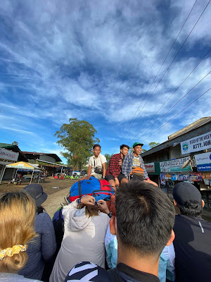
We began our hike to Tinikaran Camp Site at around 9:30 in the morning. The weather was favorable for our journey that day, and there was no indication of rain. Around 11:30 in the morning, we arrived at Big Rock e-camp, where we had fried chicken and ham for lunch. Our delicious meals and the itinerary for the three-day adventure are handled by the Explore Mt.Apo team. You can contact Arj Membrado Seron through his mobile number +639060593011.


We traveled from Big Rock to Tinikaran Camp for about two hours and spent the night there before continuing to the summit the next day. We set up camp beneath moss-covered trees and spent the afternoon chatting. After a delicious dinner, I went to the washroom to take a shower, but the water was so cold that I couldn't bring myself to bathe. Instead, I prepared for bed, knowing we had an early trek the following day.


DAY 2.
We packed our stuff about 2:00 in the morning in order to resume the ascent. This time, the pouring mild rain made the trek more difficult. The rain and the wind that touched our cheeks make us shiver as we hike. They said, there will be a few landslides when the rain gets stronger. But, we are grateful because the rain stopped before we reached the Boulder face.
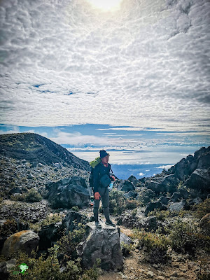
At 5:13 in the morning, we reached the Boulder. We are exactly on time as the sun finally emerges. Everything that is touched by the morning sun, glows. We were astounded by the scenery as sun rays highlighted the surrounding. Our freezing bodies are energized by the heat, which also gave us courage to continue in reaching the summit of Mount Apo.


 |


After an hour of hiking in Boulder Face, we reached one of the best spots on Mt. Apo, the White Sand. This spot is remarkable as I felt like I'm not in the Philippines because of the beautiful, towering rocks beside it. In the middle, the area has white and fined stones and surrounded with wild berries that we really can't resist to taste. And since some of us ran out of drinking water, Arj, our tour guide, accompanied to find some water to drink. And there he saw a rock with a small pool of water on it. He told us that it is safe to drink because it is rainwater. Our thirst was quenched after drinking its cold water and filled our bottle to hydrate us for the next ascent.


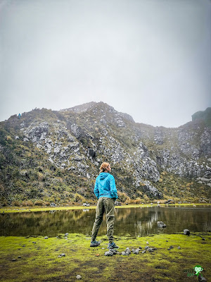
Our guide informed us that the summit was barely a kilometer away. We stopped at White Sand for a break before continuing our journey. The trail here was excessively steep. Without the surrounding plants, I’m sure I would have felt disoriented looking down. Twenty minutes later, we arrived at Crater Lake.
After taking some photos at the crater, we continued towards the summit. This was our final ascent, and we were excited to set foot on the highest point in the Philippines. The wind was strong, and occasional rain gusts made the air even cooler. However, our extreme fatigue dissipated when we reached the summit. Every now and then, the clouds parted to reveal the beautiful landscape below. The sight was so moving, it brought me to the brink of tears. It was amazing to watch. The happiness I felt at that moment was profound and heartfelt. Everything was beautiful.

 |


To be continued..

Comments
Post a Comment